The Rock channel dries at low water springs but is a possible short cut to/from the west at other states of the tide.
Coming from the west, the Meols Buoy (yellow: Pipeline, aka Sewer) is a good offshore mark. Then one has to get around the sandbanks by following waypoints: Rock, Corner, Chip. Then pass close to (and north of) the perch (no. 11, fixed green light) at the end of the groyne which heads NW from the Perch Rock Lighthouse. [Note that no. 11 Perch has been replaced at a position 10m south of the original as of 2020, but with some of the original perch left as an obstruction]. Beware strong currents near the groyne: heading for the groyne itself and then turning to port near it (when inbound) to round the perch is optmium. In this area the sea state can be very confused (as the waters from the Rock and Main channel mix). The confused water is usually the deepest part. From the perch head for Brazil Buoy. Do not head for the next perch (no. 12) since there is a shallow area protruding between the two groynes.
Although many wrecks are charted, only two showed in 1995 at low water springs and then only by a metre or two (see Wrecks of Liverpool Bay Vol II for images) - these are charted as drying 3.6m and 3.9m. I surveyed them in May 2016, and the latter one gave a small and isolated sonar return (see here) -- suggesting that they may no longer dry.
In March 2017 I re-surveyed the Rock Channel near waypoint CHIP (the
shallowest part) and found that the Brazil Bank edge had moved South so
that my CHIP waypoint was quite close to the northern edge of the
channel. See here. I have moved the waypoint
100m south to re-locate it centrally in the channel. This survey also
suggests that the depth in the Rock Channel has increased - and that it
does not now dry at extreme LW [CD].
I passed through the Rock Channel surveying in April 2019, and my depth survey confirmed the track between my
waypoints (central to plot) as drying less that 1m at CD [Lowest
Astronomical Tide]. I confirmed this again in May 2020 and June and September 2021.
Note that locally laid (and unlit) buoys are often to be found close to waypoints Chip (race mark: yellow sphere marked WYC CHIP) and Corner (black buoy). On 13 May 2015, only Chip was present. Another race mark "Lagoon" was near to the Southern end of the west training wall.
Waypoints used by me (my boat draws less than 1 metre). Do not rely on these - check yourself near HW first.
Bearings (out/in going): Perch to Chip 271/91 degrees; Chip to Corner 279/99 degrees; Corner to Rock 294/114 degrees: Rock to Meols(Pipeline) 267/87 degrees.
Several times a year (latest Aug 2016; April 2017; April 2018, April 2019, May 2020, June 2021, Sept 2023). I follow these waypoints and find minimum water depth corresponding to seabed at 2 metres (or less) above Chart Datum (between Chip and the perch at the end of the groyne). From Rock to Meols (Pipeline) you cross the tail of the North sandbank with seabed level corresponding to 1 metre above Chart Datum. So at half tide (5.2 metres above CD), you should have a minimum depth of 3 metres in the Rock Channel.
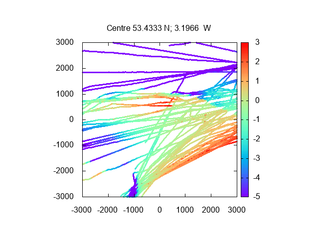
Images of my tracks and depths from 2014 - 2020 (units metres;
depths from CD):
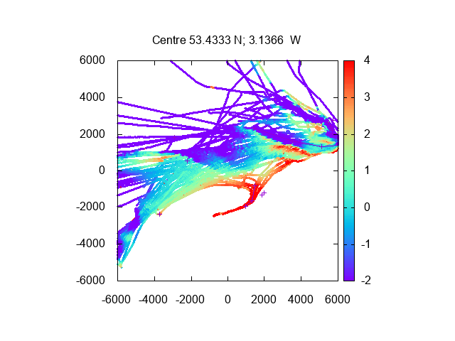
Overview of N Wirral Coast (Hilbre Swash to
west, Rock Channel to east, Meols access to south)
Enlargement of North Bank Centre is west
of waypoint "Corner"
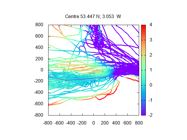
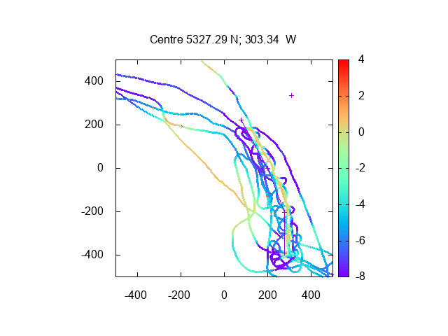
Bar in Rock Channel (waypoint Chip to west;
Brazil Bank near centre, end of groyne (No 11) to east);
Rock Gut Showing Rock Channel around south of Brazil
Bank and also the Rock Gut which is less deep and cuts through the
Brazil Bank further north.
Crossing E Hoyle Bank/Spit (Hilbre Swash
to west and East Hoyle Spit to North (best route just dries only at very
low tides).
A record of the depth and track of all my voyages (from 2013) is
also available from
teamSurv . Note that some of the sand banks seem to have moved
during this period. [seems defunct as of 2019]
The chart of the Rock Channel area is from surveys around 2004 and
earlier and shows a discontinuity between different surveys. I have
surveyed this area myself (see images above). The chart shows two other
possible routes: The Rock
Gut (info here) that is named on the chart, and a route that runs close to the
western side of the southern end of the training
wall and then snakes between sandbanks (Murphy's gut). This latter route
does exist and does have greater depth in part, but it is not very
practical, since it runs so close to a solid obstacle: the training wall
which is a line of concrete/rocks that dries up to 2.5 metres or so.
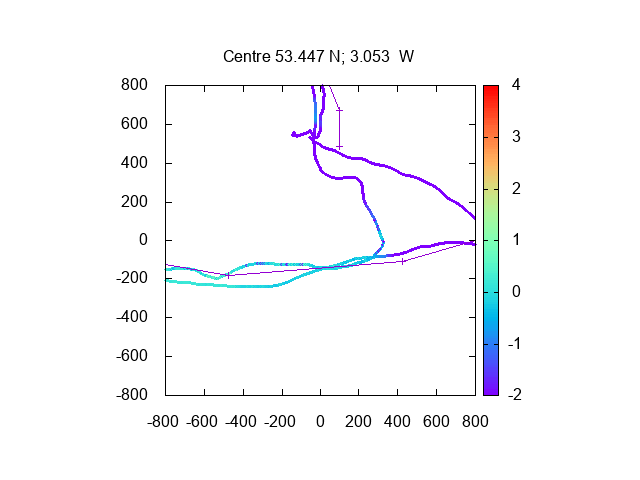
Even more worrying, I find that the precise location of the training
wall is different by 20 metres or more (it is further east) from that
charted in this region. See my 2016 to 2019
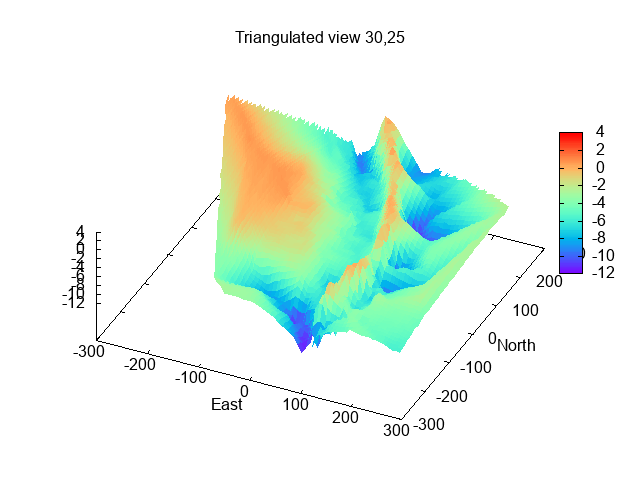
survey of Murphy's Gut [lines represent charted training wall] and
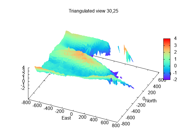
3-D image of the narrow Gut between the
Brazil bank and the Training Wall.
Zoomable chart from
Navionics.
Some extensive information (some historic too) from Liverpool Yacht
Club here . Now
updated to 2018.
This gives waypoints which are a little different from mine.
See also a 2014 guide from
Liverpool Sailing Club.[link dead]
Historical Information: Denham's 1840 Sailing Directions to the Rock Channel (also contains information on
lighthouses, northwest lightship and lifeboats).
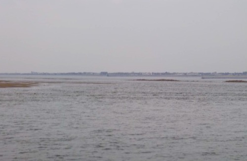
See also an image near LW (0.6m above CD) showing the narrow
Gut between the Brazil Sandbank and the Training Wall.