Irish Sea Pilotage
Chris Michael
Jump to: Wales , Scotland ,
Isle of Man , Ireland,
England.
Harbours (and some anchorages) in the Irish Sea. Here I gather
information available on the web plus some information from my own visits. Places highlighted in bold have fuller
navigation details from my surveys.
See below for a list of guides available to purchase.
For another web guide (mostly 2004) see here[discontinued].
Some (smart phone optimised) web info is also available for free
from Visit my Harbour,
or
here[link dead],
or eOceanic for Ireland.
Liverpool tide table
Weather sources (clickable)
Irish sea wind forecasts from POL
[now discontinued] and xc
Wave height forecasts (wind and swell waves) are available from
POL [now discontinued] or from
Mersey mouth or from
Weather online.
Real time wave heights from
CEFAS
Chart information.
Windfarm
list and interactive map.
Subsea cable charts from Kingfisher
Information about Firing Ranges in the Irish
Sea area.
An up-to-date chart (zoomable) is available free
from Navionics.
Or see
here for already zoomed.
Also C-Map
online chart which allows lat and long to be read off by clicking.
Fishing boat port codes: here [defunct]
In order around Irish Sea (clockwise from Mull of Galloway):
WN DS; CL MT WO WA BW LR FD PN LL MR RN CH; BS CO AB CA M;
W WD D DA DK; N B;
Note: Kirkcudbright vessels seem to favour register BA (Ballantrae
which is a small registry port 12 miles south of Girvan)
[IOM: DO CT PL RY]
England
- Dee estuary:
Chester, Heswall, West Kirby,
Meols
- Mersey estuary: Liverpool
and here,
Manchester Ship Canal,
Widnes,
Fidlers Ferry,
Alt
- Ribble Pilot;
Ribble estuary : Lytham, Freckleton, Douglas, Preston
- Blackpool.
- Fleetwood,
Wyre (Wardleys and Skippool)
- Lune buoyage and
navigation[needs subscription],
Glasson Dock Marina
- Morecambe Bay;
Morecambe and Heysham;
Morecambe;
Lancaster.
- Piel,
Glasson S C Piel Moorings,
Barrow S C,
Barrow more,
Walney Channel
- Duddon estuary: Haverigg;
More ;
Port Millom;
Askam Pier also location
of Mersey Flat Oakdale
- Ravenglass,
also
- Whitehaven
- Harrington
- Workington
- Maryport
- Silloth
Scotland
Wales
- Ramsey Sound (St. Justinians)
- Porthgain
- Fishguard
Yacht club
- Newport
- Teifi estuary
- Newquay
- Aberaeron
- Aberystwyth
- Aberdyfi
- Barmouth
- Porthmadog to Aberdyfi Guide
- Mochras Lagoon
more
-
Llŷn
harbours:[historic]
- Porthmadog
more
more
- Criccieth
more
- Pwllheli
more
- Llanbedrog
- Abersoch
more
- Aberdaron
more
(Porth Meudwy)
- Bardsey
- Porth Ysgaden
- Porth Dinllaen
- Trefor
- North Wales tidal info
- Anglesey Crib [note Rhoscolyn is
wrongly located],
- Menai: Abermenai,
Caernarfon,
Bar info,
Caernarfon marina,
tides,
Dinorwic marina,
Swellies,
Menai Bridge,
Bangor,
Beaumaris,
more,
Puffin Island.
- Llanddwyn
- Cymyran
- Rhoscolyn,
more
-
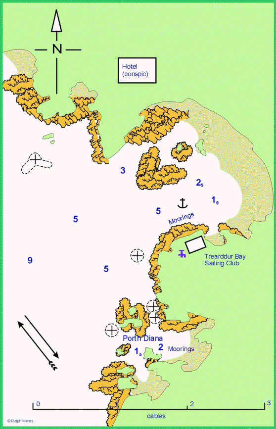
Trearddur Bay
- Holyhead
Marina[storm damage 2 March 2018 - image of status May 2019],
Holyhead
-
Skerries anchorage, Wrong way!
- Cemlyn
- Cemaes, my visit ,
more
- Porth
Wen,
more
- Amlwch,
more,
more
- Traeth Dulas
- Moelfre,
more info
- Traeth
Bychan,
more.
- Traeth Coch
(Red Wharf Bay); more
- Conwy;
Conwy Access;
marina(Conwy);
marina(Deganwy).
- Llandudno.
- Rhos ,
more
- Rhyl
- Dee estuary: Mostyn, Connah's Quay
Isle of Man
Northern Ireland
Republic of Ireland
Published Guides
- Yacht club sailing directions available as books:
-
Clyde to Solway 2020;
Sample pages
- Solway 2011
-
East and North Coasts of Ireland (11th ed 2008; 12th ed 2014; 13th ed 2020)
updates to 2017,
updates to 2018,
latest update
- Isle
of Man Sailing Directions, Tidal Streams and Anchorages (2009, 2011
and 2019)
updates
- Dive Guides by Chris Holden which give lots of detail about the
coast of North Wales:
eBooks: Barmouth
to Dinllaen;
Dinllaen to S Stack.
- Commercial Guides:
- Reeds Nautical Almanac (also Western Almanac) 2022 (annual)
(updates may require a password or only be available by e-mail).
- Cruising Anglesey
and adjoining waters from Liverpool to Portmadoc, Ralph Morris, (9th ed. revised 2016).
[link dead]
Anglesey Crib.
- Cruising Guide to Anglesey and the Menai Strait
including Conwy, Robert Kemp 1978
- Cruising Guide to the Isle of Man, Robert Kemp
1979.
- Anglesey and North Wales Coast Pilot, Henry Glazebrook and
Norman Sheldrick, 1961.
- A cruising guide to northwest England and Wales, George Griffiths 1993
- Lundy and Irish Sea Pilot, David Taylor, 2nd ed: 2001
updates (2004)[link dead].
-
Irish Sea Pilot David Rainsbury. (new ed. 2015)
updates[link dead].
Back to index here